
US Climate Prediction Center issues La Nina Watch alongside El Nino Advisory
In the first week of January, we said that La Nina is more likely than either El Nino or neutral conditions by spring this year. This past Thursday February 8th, the US Climate Prediction Center maintained an El Nino Advisory but also issued a La Nina Watch. This is because El Nino is still active in the Pacific Ocean, but conditions are considered favourable by the US agency for a transition to La Nina within the next six months. In contrast, the BOM says it’s too soon to make such a forecast.
El Nino going down fighting
The current El Nino is going down fighting as the atmosphere links back up with the ocean. This recoupling of the atmosphere with the ocean will see more typical El Nino conditions briefly affect Australia before the Pacific Ocean shifts to neutral conditions during autumn. Recent large negative values of the Southern Oscillation Index show this recoupling (helped by a break period in the North Australian monsoon).
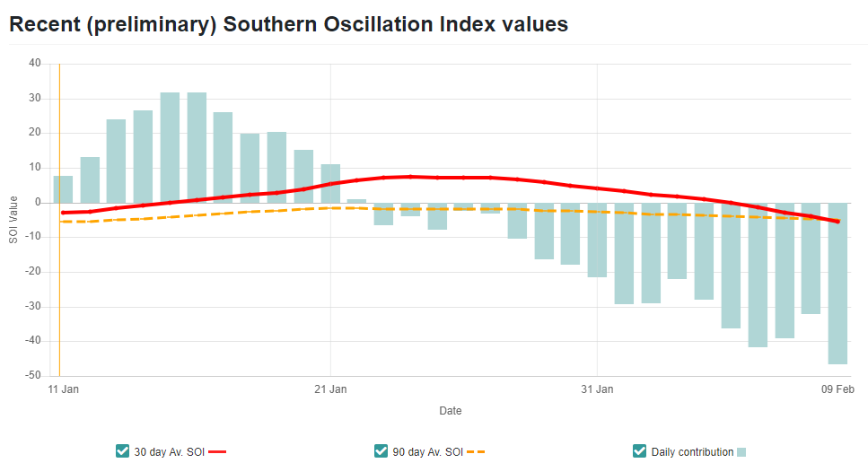
Image: SOI values (green daily, red 30 day average, orange 90 day average). Source: longpaddock.qld.gov.au
In the end of 2023 and through January 2024 the atmosphere became uncoupled from the oceanic component of El Nino. One of the factors leading to this was warmer-than-average sea surface temperatures in the western Pacific during December and especially during January which is extremely rare with an El Nino when those waters should be colder than average! The warming in the Coral Sea occurred rapidly and the southern part of the Coral Sea has remained warm into February. Oceanic models that were run several months prior did not predict that the Coral Sea would become so warm during this period, which had consequences for the seasonal forecasts made last year as well as the tropical cyclone activity (models did correctly predict the warmth of the Tasman Sea). The warm waters in the western Pacific will continue to have consequences for the seasons ahead.
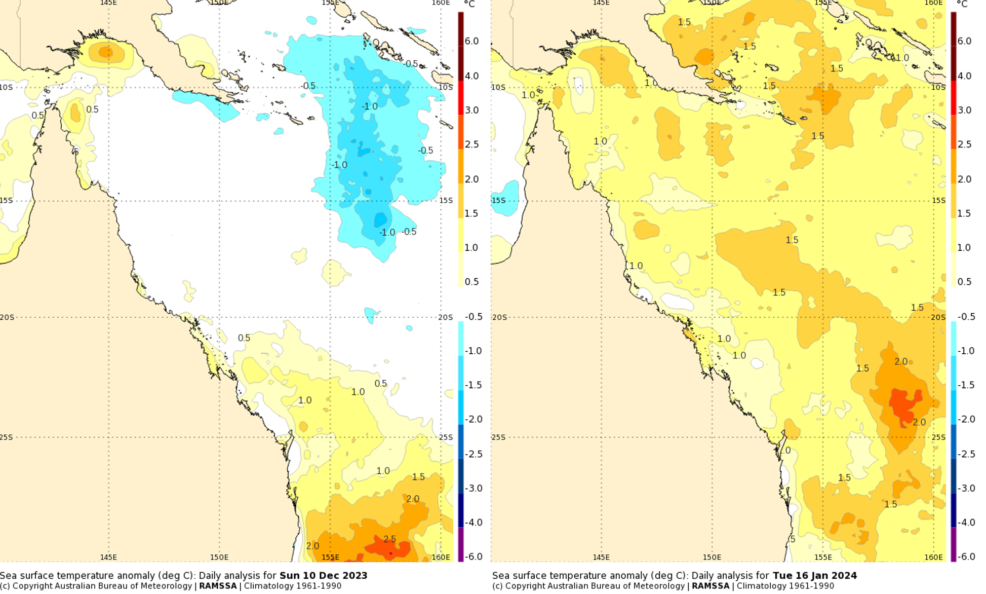
Image: Recent daily sea surface temperature (SST) anomalies. Left: SST around average on Sunday 10 Dec 2023 (Tropical Cyclone Jasper was present at the time, causing a trail of colder water). Right: SST well above average on Tuesday 16 January 2024 (before Tropical Cyclone Kirrily developed). Source: BOM
Increasing chances of a transition to La Nina
Most oceanic models are predicting a La Nina to develop in the second half of 2024. Now, models can be wrong like when the pre-eminent model from the European Centre predicted neutral-to-El-Nino conditions in 2022 but a strong La Nina continued without weakening. But the same model did very well last year in predicting an El Nino.
But our prediction isn’t just taking models at face value. As we showed you last month, there is a recent historical precedent for a transition back to La Nina (2007 to 2011), and since 1998 La Nina has been the more common ENSO state due to the current state of a longer-term climate oscillation. Even more importantly, the observations below the surface of the equatorial Pacific show cold water making its way towards the surface. The following animation from December 2023 to February 2024 shows the observations of sub-surface temperature anomalies in the equatorial Pacific Ocean down to a depth of 450m below the surface.
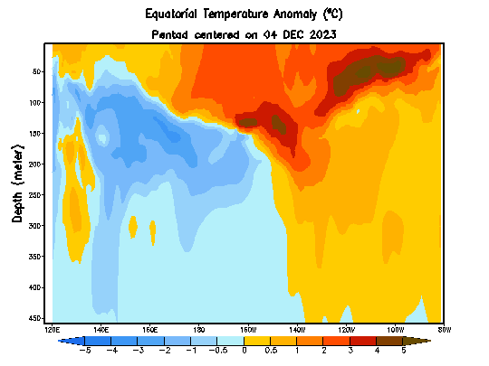
Animation: Subsurface temperature anomalies for the equatorial Pacific from December 2023 to February 2024. Source: US Climate Prediction Center (CPC)
This is crucial for the seasonal forecasts because when the cold water reaches the surface it will cool it, leading to an end to El Nino and then a transition to La Nina. It would be very difficult for an El Nino to redevelop after the cold water reaches the surface. These observations of what is really happening give confidence that the model predictions are going in the right direction. The US Climate Prediction Center predicts El Nino to end during the Southern Hemisphere autumn and then for a transition to La Nina potentially occurring during the Southern Hemisphere winter. The North American models predict the fastest transition occurring in our winter whereas the European model predicts a slower transition later in winter and early spring.
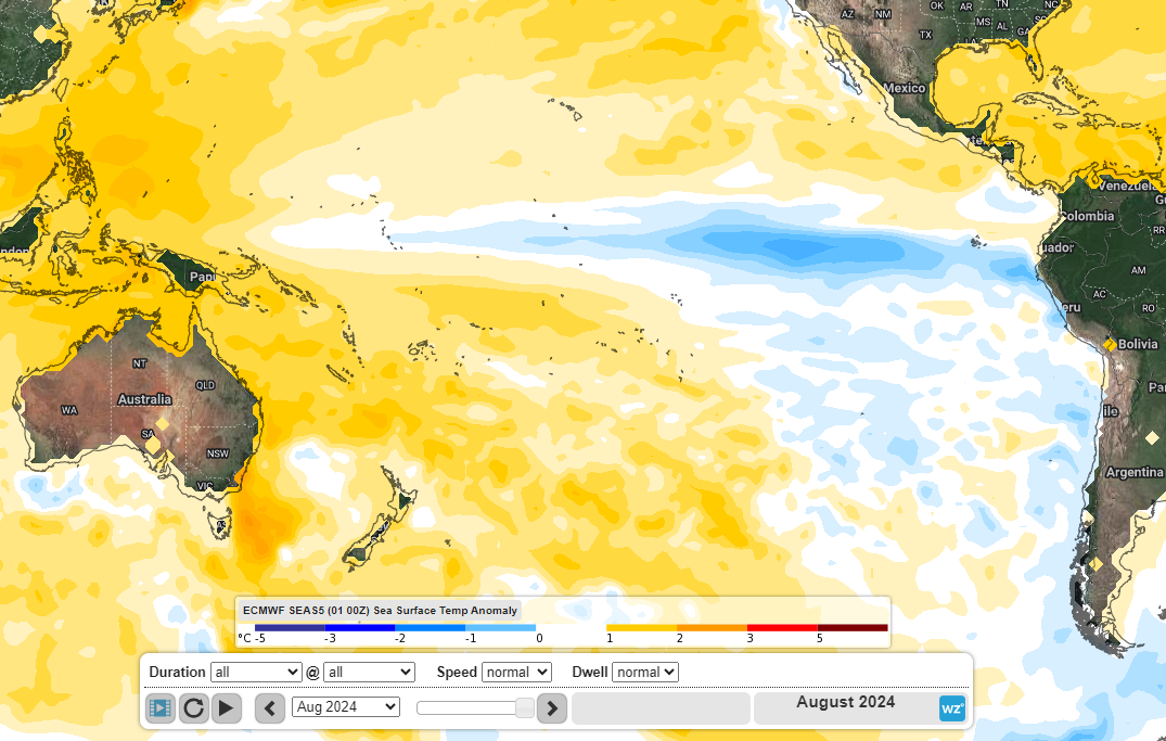
Image: ECMWF forecast sea surface temperature anomalies for August 2024.
Here is the latest probabilistic forecast from the International Research Institute for Climate and Society:
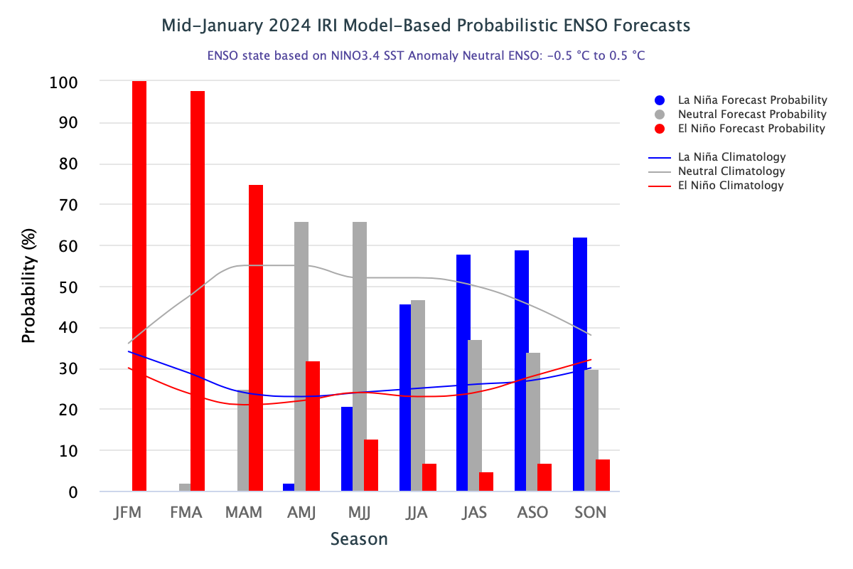
Image: IRI model-based probabilistic ENSO forecast. Source: IRI
Potential impacts if La Nina returns
The warm waters of the western Pacific that have worked at times to weaken the effects of El Nino this summer would actually work to strengthen the effects of a La Nina. The atmosphere would be more consistently linked with the oceanic component of a La Nina because the contrast between the warm waters in the western Pacific and the cold waters in the central and eastern Pacific would strengthen the trade winds and concentrate rising motion, low pressure and moisture to the north of Australia.
Looking at past years when a transition from El Nino to La Nina has occurred may give us some idea of the potential rainfall for this year. In those years, spring and summer have been the most impacted as this is when the La Nina had developed, with more precipitation than average in eastern and northern Australia. During autumn there was much more rainfall in northern Australia, slightly less in northeast NSW, and little difference from average elsewhere, and during winter there was increased rainfall for southeast QLD and northeast NSW. And SA and WA (except for the north) saw the least differences from average throughout each season.
![]()
Image: Historic seasonal rainfall anomalies during years when a La Nina developed following an El Nino. Data: NOAA
Weatherzone will keep you updated about the state of the Pacific Ocean and the associated weather for Australia throughout the year.