
Generation gone with the wind
A weeklong stretch of low wind power was broken on Wednesday evening, as a weak cold front marched across southern Australia.
The chart below shows that the National Electricity Market (NEM) has endured a weeklong stretch of low wind generation, with wind power providing around 6% of the NEM’s electricity, down from last year’s average of 13.1% (Mon, April 15 to Wed, April 17). .png)
The daily wind generation has been under 41 GWh/day for the last seven days leading up to Thursday, April 18. The calmest winds occurred on Sunday, April 14 with only 24 GWh/day produced or 4.6% of grid demand.
To put this in perspective, the average daily wind generation during the last year up to Wednesday, April 17, 2024, was 71 GWh/day, according to data from the open NEM.
This prolonged period of low wind was caused by blocking high pressure systems sitting over southern Australia, forcing cold fronts or strong wind further south.
The image below shows the Mean Sea Level Pressure chart on the calmest day, Sunday, April 14, with high pressure stubbornly sitting over the southern half of the country.
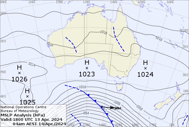
Image: Mean Sea Level Pressure Analysis at 4am AEST on Sunday, April 14. Source: Bureau of Meteorology.
As we mentioned earlier today, a positive Southern Annular Mode (SAM) has led to consistent high pressure systems positioned over latitudes well south of Australia during the first three months of the year and during this week. This has kept cold fronts south of the mainland, and even south of Tasmania.
The period of light winds ended abruptly on Wednesday evening, with WattClarity reporting that wind production peaking above 3,000 MW at 9:10pm AEST.
The increased wind power on Wednesday night, was caused by a couple of factors;
- A weak cold front swept across the southeast on Wednesday, bringing stronger winds.
- A very shallow temperature inversion formed in the early evening protecting the surface from the stronger winds, but the wind turbine hub-height (150 metres above the ground) winds remained strong at around 28-38 km/h in SA.
Temperature inversions form at night when the ground cools quicker than the air above it, meaning that the temperature increases with height for a thin layer of the atmosphere.
During autumn, the temperature inversions are commonly shallow meaning that while the wind could be weak at the surface, the hub heights could continue to experience strong winds.
A similar phenomenon could happen again tonight across southern Australia, with another cold front passing across the south.
Looking ahead, light winds are expected to continue from Friday as a stubborn high-pressure system builds over the Bight until early to mid-next week.